The Warburton Mountain Bike Destination Project Risk Management has been slow to acknowledge the serious risk of bushfire and the strain on our emergency services due to Mountain Biking injuries. It would have been more appropriate to have considered the impact on our emergency services and our local community from the beginning. It wasn’t considered in the Warburton Feasibility Study of 2013. It wasn’t mentioned in the risk assessment documents of 2016 and 2019 even though the guidelines of risk assessment insists that any likelihood of death, injury or destruction of property must be included in that document. Funding was allocated on the basis that there was no risk to life or property as set out in these documents.
The Bushfire Management Statement & Plan (draft) finally appears in September 2019.
And now we have Appendix G Bushfire Management hiding in the back of the Warburton Mountain Bike Destinations EES Technical Report on Land Use and Planning. Without any indication in the table of contents that there is anything in the EES documentation that addresses bushfire, this starts on page 313. Given it is one of the major concerns of residents, they are not making it easy to find.
This document:
- suggests the development for an Emergency Management Strategy that will be developed sometime in the future. Still not yet.
- rates the bushfire risk as LOW even though we live in an extreme risk area for bushfire – one of the most bushfire prone areas in Victoria.
- states there will be less problems with the 221,454 mountain bike visitors because there will be opportunities of warning them of the risks at the parking hubs and on shuttle buses. 221,454 extra visitors per year who will be up on our most fire prone mountains are going to be a lower risk than 221,454 less? Not likely, especially when they will be out remotely on the very mountains that are the most fireprone. Who is going to call them in if a fire starts? And try evacuating through our one narrow road out of town that happens to be cut into the side of our most fire prone mountain of all. When Mt. Little Joe goes up there is no road in or out.
- where are the mountain bikers to go to shelter? To our fire refuges. Sound good? Our fire refuges hold 380 (Millgrove) and 270 (East Warburton) people in them. There are over 5,000 locals in the area and then there will be another 5,000+ mountain bikers per week and if the mountain bikers don’t scare away our other tourist visitors then some thousands on top of that. Who gets into the refuges and who gets to burn outside?
- states that the trails will be closed on Code Red days. Problem – how are you going to close 177kms of trails through the mountains? Not possible – not completely. It also recommends that perhaps other Bushfire Rating categories may be for closing too, but is all over the place with which categories. It says in two places that perhaps the trails should be closed on Very High, Extreme and Code Red. Not on Severe then? Anyway, if it closed on the four top categories then they would be closed all summer. Not likely.
- states that in the event of a fire the roads up Mt Tugwell will be clear for emergency services and helicopters will be able to operate to evacuate. Not if the fire starts down low and races up the mountain. We all know that a fire can cut off Warburton Highway and then quickly do the same to Old Warburton Road cutting off access to firefighters and that choppers can’t operate if the fires are too fierce or too smoky. Ask a CFA volunteer and they will let you know that they will not take a risk of driving through a firestorm, and much less getting out of their trucks and running through burning bush to find lost mountain bikers. Why should they?
Fire Risk
If a bushfire occurs, the many mountain bikers will cause a great strain on any evacuation. It is reprehensible to load a projected 5,000+ mountain bikers per week in addition to other visitors and our locals, many of them scattered throughout the hills on trails isolated from easy contact. Evacuation off the mountains and on our narrow roads with the choke point on Warburton Highway is highly problematic. It is not something that should be considered an afterthought, after the decision to build has been made and the funding for it has been acquired.
The Fire Management Statement & Plan 2020 (Draft) offers a management strategy for Bushfire risk.
It admits we are in an extremely dangerous bushfire risk area and also admits that mountain bikers will be out on isolated trails and not within easy access of local townships.
There solution is to close all trails on Severe, Extreme and Code Red fire danger alert days and also to close all remote trails on High and Very High fire danger days. Locals know that would effectively close the trails for the entire summer period, the last month of Spring and the first month of Autumn. However, it contradicts itself, in that later in the document it talks only about closing trails on Extreme and Code Red days – and these are the remote trails. So which? Well the updated document Appendix G Bushfire Management in the EES just says Code Red. So now we know.
Observing how impossible it is to stop mountain bikers accessing the trails already I doubt this will work. Mountain bikers make trails around gates and other infrastructure designed to keep them out. The Plan also suggests signage would help inform mountain bikers – however our experience of mountain bikers is that they ignore and vandalise signs.
Failing that, the mountain bikers are to be evacuated to our Fire Shelters or Neighbourhood Safer Places. Our Fire Shelters hold just 380 and 270 people while we have of over 3,000 residents in Warburton and Millgrove alone. Add tourists and you have a disaster. The Neighbourhood safer places are not very safe.
Locals asking tourists if they checked the fire ratings before visiting has revealed that most simply don’t so they will come here anyway.
The Plan suggests creating an Emergency Planning Committee whose job will be to evacuate the mountain bikers. There is to be a full time warden and a deputy warden and then extras hired over high fire danger periods. The wardens are to be supplied with vehicles and two way radios. All visitors are to sign in and receive fire safety training. That will be a really big undertaking – and are you noticing the expense here? Someone will have to be at every trailhead stopping all mountain bikers, checking their gear is appropriate and giving them the training.
Scenic Warburton Bushfire Risk Highest in Victoria
This article highlights the fire risks of living in the Upper Yarra Valley that makes it clear that an extra load of tourists here will make things far more difficult:
And so does this video put out by the CFA which discusses all the issues that residents worry about particularly with a large extra population of tourists, with 4,000+ extra mountain bike riders needing to not just be evacuated but to be evacuated off remote locations on the mountains among dense bushland.
CFA Know Your Risk Yarra Valley video
Some quotes from the video:
“(Launching Place, Warburton etc) . . .it’s time and distance so it can take some time for us to get to some of those places. All of those places are at high risk of bushfire.
“This area is very dry, it is very prone to bushfire. We are very vulnerable because we just have one highway going in and going out. Egress is an issue if there is going to be a fire.
“With traffic issues already on the Warburton Highway and many houses surrounded by dense bushland, getting 12,000 people out of here in a hurry if a major bushfire hits is one of our biggest challenges and biggest concerns.
There is also a section where a fire truck has to cross onto the wrong side of the road on a narrow bend because there are road bikes riding multiple abreast blocking the entire left hand side of the road.
This video features Forest Fire Management Victoria Chief Fire Officer Chris Hardman on January 17 at 2:43 PM in which he says:
“Surprisingly for me we are still finding that even where we have a Total Fire Ban people are still lighting camp fires. That is irresponsible and it can lead to devastating bush fires which impact rural communities and could impact people’s lives.” Vic Emergency Video
Health Risks
Mountain Bikers will have accidents (they already do in our area) and our local paramedic/ambulance services (and medical clinics and hospitals) will have to respond to these eventualities. They are already strained to excess as described in a newspaper article in the Mountain Views Mail:
TRIP The Ambos Story – 13 August 2018
Referring to the overstretched services in the Yarra Valley, Mobile Intensive Care Paramedic Jason Callanan says:
“Your brother who is short of breath having an asthma attack, we can’t get to him in time because we’re dealing with this (an avoidable car crash). To another. “Your baby sister who has croup, we can’t get to her in time,” and another, “Your mum or dad who has chest pain, or could be having a stroke, we can’t get to them either, because we’re dealing with this; and it’s something that could have been avoided.”
So what will happen when those paramedics are instead dealing with Mountain Bike Casualties, something else that was entirely avoidable? And this is further complicated by the remote trails that the Ambos will have to go out to, in order to retrieve injured Mountain Bikers.
Warburton Mountain Bike Destination – Risk Management Assessments
Accidents and injuries are not mentioned in The Warburton Mountain Bike Hub – Risk Management Plan 2016, in their Economic Assessment of Health and Recreation Benefits Final Report Dec 2019 nor in their Warburton Mountain Bike Destination – Qualitative Risk Management Assessment Dec 2019. They barely rate a mention in the EES documentation release of 2021 – even then it is not considered a problem due to some future plan that will manage it that hasn’t been produced yet. This despite the Socio-Economic Impacts Assessment stating that the loss of residents caused by the building of the mountain bike trails will reduce the number of people volunteering in our CFA and SES.
When preparing a Risk Assessment it is advised to include the likelihood of death and serious injuries as an outcome. The likelihood of a death caused by injuries occurring on the WMBD is a probability, while serious injury is a definite. The silence on this in their early risk assessments is a serious omission, especially considering funding was allocated to the Warburton Mountain Bike Destination based on these useless risk assessments.
These assessments are supposed to be based on the Australian Standard AS/NZS ISO 31000:2009 Risk Management Principles and Guidelines as a guide
The Warburton Mountain Bike Hub – Risk Management Plan 2016
Economic Assessment of Health and Recreation Benefits Final Report Dec 2019
Their plan was supposed to include these risk criteria:
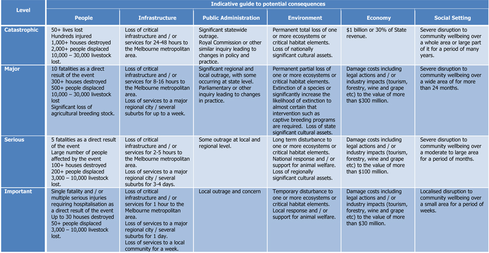
Yet nothing was said about risk to human life or health through injury or fire risk. Only economic considerations and the ‘low risk’ of political fallout. Notice how serious a fatality is rated, that injuries requiring hospitalisation should be included.
Even though the guidelines mention risk to wildlife, nothing was said about the loss of habitat to an endangered species (ie Leadbeater’s Possum) or to other wildlife, from disturbance of their habitat or increased risk of injury on the roads from increased traffic.
Nothing was said about the social impact, that will cause disruption to community well-being.
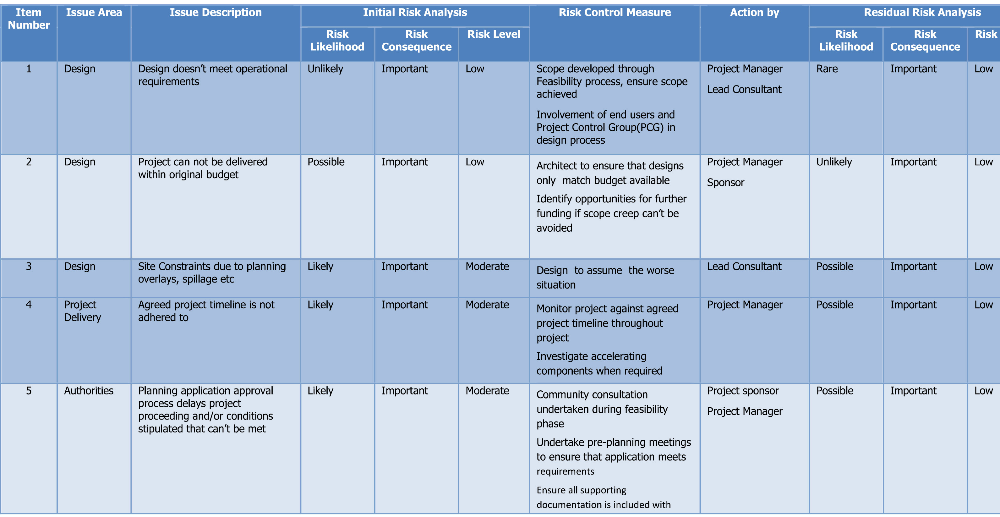
All the risks evaluated were about construction delays, planning permit blow outs, budget blow outs, traffic disruptions (during construction only), etc. with one ‘low risk’ concern that there may be some political risk from the community (page 11):

Please note that approaches to the council and other authorities have been undertaken by multiple groups and individuals. There has been little mitigation to warrant the ‘residual’ risk.
The risk assessment used the Australian Standard AS/NZS ISO 31000:2009 Risk Management Principles and Guidelines as a guide.
